With Olver's retirement, the boundary's of the congressional map are becoming clear. Neal's district gobbles up the Berkshires and the Valley. McGovern and Tsongas get the balance of Worcester County, while the rest of the southeast baconmander gets squished Westward. Right?
Wrong!
Several things wrong with this scenario. First of all, the people of Western Mass have said over and over again they do not want to be merged into one district. (Western Mass, for my purposes, is Berkshire, Hampden, Hampshire and Franklin counties.) This position will require both districts to take a good deal of Worcester County, possibly electing a rep from there, but that's less of an issue, since such a rep would still be beholden to represent Western interests, since the majority of his constituents would be there. Secondly, the ultra liberal areas that form the base of the current MA-1 do not like pro-life Richard Neal. He would be a bad fit for the new district. He is a much better fit for his current working class urban Democrats, plus relatively conservative Southern Worcester County set up he has currently. He will not want the boat rocked. Giving him a "safe" district entirely within Western Mass is a recipe for a primary challenge.
Perhaps most importantly the chair of the redistricting committee is none other than Stan Rosenburg, the Amherst State Senator who replaced John Olver after his congressional victory in 1991. He will protect Western interests and not allow just one district.
Lastly there are rumors. newsmaven242424 did a good job writing them up, and my map is somewhat similar to his. I feel that Rosenburg probably had advanced warning of Olver's retirement and put these out intentionally to soften up the delegation for his plans.
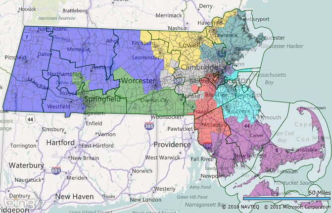
Without further ado, I present my map:
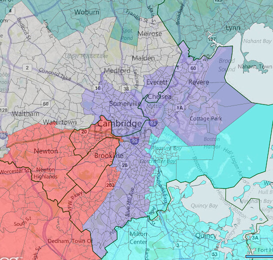
Boston Detail:
No city or town is split other than Boston. All population variances are less than 0.1%.
2010 governor results are from the Boston Globe, so probably are election night rather than final counts, except for City of Boston, whose precinct data I downloaded from the city website. The difference in these counts is usually fairly small, since only military absentees are allowed to arrive late. In every case, the current delegation out performed the governor, so this should represent something of a floor, for a non-special election.
MA-01 (Jim McGovern vs. Andy Nuciforo) - Blue
Patrick: 130,117 Baker: 90,747
This trades Fitchburg and the Nashoba Valley area for Worcester and its some of its suburbs. In principle McGovern should be happy, since he's being given a safe district without an incumbent, but he's being set up for a region loyalty based challenge. If Nuciforo can convince Western Mass that a man from Worcester, no matter how liberal, shouldn't represent them, he'll win.
MA-02 (Richard Neal) - Green
Patrick: 105,712 Baker: 105,007
Neal's district is largely unchanged, gaining Holyoke in the West and Franklin in the East. It should be completely safe for him and reasonably safe in an open seat scenario.
MA-03 (open) - Purple
Patrick: 130,280 Baker: 123,298
Keating could run here, but he would probably lose to an ambitious state senator if the primary field does not fracture too much. Keating, whose base is in Quincy and Norfolk county, doesn't have enough influence on Beacon Hill to stop this and will get double booked with Lynch.
MA-04 (Barney Frank) - Red
Patrick: 129,911 Baker: 110,443
Frank's loss of New Bedford and the South Coast and it's replacement with some fairly conservative turf is assuaged by giving him Allston/Brighton, West Roxbury and half of JP, keeping his district safe D.
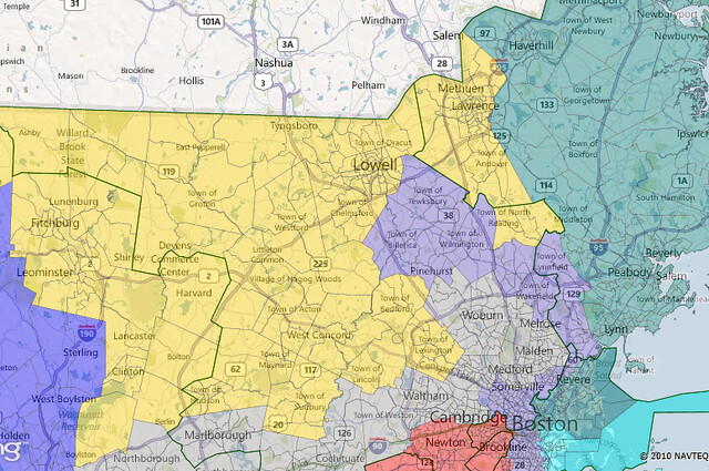
MA-05 (Nikki Tsongas) - Gold
Baker: 116,726 Patrick: 104,540
Our first Baker district. Tsongas is given some new turf to the west, which makes her district slightly swingier.
MA-06 (John Tierney) - Teal
Baker: 143,170 Patrick: 118,613
Tierney adds some fairly conservative towns. The Baker numbers are a bit inflated here because he is from the North Shore.
MA-07 (Ed Markey) - Gray
Patrick: 140,387 Baker: 117,125
This district shifts westward, stretching to the Worcester suburbs. Still safe D.
MA-08 (Mike Capuano) - Periwinkle
Patrick: 135,858 Baker: 39,972
Picks some white working class cities, loses parts of Boston. Still majority minority, though not by VAP. This is not a VRA district.
MA-09 (Stephen Lynch vs. Bill Keating)
Baker: 116,360 Patrick: 112,926
I would say advantage Lynch, due to greater voter familiarity and a larger share of the territory. Keating will have to make this idealogical to win by peeling off liberals in the Lynch areas. Either man should be safe in the general.
What could be better?
The 5th and 6th districts are a little too Republican for safety this can be solved, by breaking up the 8th district and giving it some conservative territory in the Northern suburbs. It would be particularly amusing if Wakefield and its environs are put in the 8th since that's Richard Tisei's base and he is planning a challenge to Tierney. Boston will protest if it is split too much, so I think such an unpacking is unlikely.
Update:
Here's another map a drew which keeps districts 1-4 and 9 the same but reconfigures the others to make 5 and 6 safer. The 8th is now up to 56% white, but, once again, this is not a VRA district. The population deviation is still within a tenth of a percent, but Revere and Burlington are also split now. Splitting Revere is necessary to keep Markey's hometown of Malden in his district and still have the 8th reach up and grab some conservative suburbs. One precinct from Burlington is in the 8th to make the population numbers work.
The new political numbers:
5th - Baker 117,938 Patrick 114,830
6th - Baker 113,889 Patrick 111,355
7th - Patrick 135,941 Baker 122,267
8th - Patrick 138,123 Baker 63,145
I did not have precinct data for Revere or Burlington so each town is counted entirely in the 6th or 7th respectively. This affects at most a couple hundred votes.
As you can see, Tsongas and Tierney get much safer districts, while only weakening Markey slightly. (Capuano can more than take it. His district is still the safest in the state and still dominated by urban areas.) This certainly messier than my first map and would be subject to crocodile tears over the "dilution" of minority strength in the 8th, but it makes our North Shore and Merrimack Valley seats safer than before.

